
]
[
currently booking spring 2026
Elevate Your Listings With Drone Services in
London, Ontario.
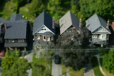
Collect quality leads and close sales faster with aerial photography and drone services in London, Ontario.
Collect quality leads and close sales faster with aerial photography and drone services in London, Ontario.
[
How it works
]
Collect Quality Leads.
Close Sales Faster.
Collect Quality Leads.
Close Sales Faster.
Professional drone services, aerial photography, videography, and single property listing websites built to attract serious buyers and move listings forward with confidence.
Professional drone services, aerial photography, videography, and single property listing websites built to attract serious buyers and move listings forward with confidence.
“The aerial photos and video completely changed how my listings performed. I had a property sit for three weeks with standard photos. We reshot with Forest City Aerial and it was under offer in four days. The quality speaks for itself.”
Sarah Mitchell
Past client
“The aerial photos and video completely changed how my listings performed. I had a property sit for three weeks with standard photos. We reshot with Forest City Aerial and it was under offer in four days. The quality speaks for itself.”
Sarah Mitchell
Past client
“The aerial photos and video completely changed how my listings performed. I had a property sit for three weeks with standard photos. We reshot with Forest City Aerial and it was under offer in four days. The quality speaks for itself.”
Sarah Mitchell
Past client


AERIAL PHOTO/VIDEO
AERIAL PHOTO/VIDEO

LISTING WEBSITE
LISTING WEBSITE
CLOSE SALES FASTER
CLOSE SALES FASTER
[
Why work with us
]
Why Agents Choose Forest City Aerial.
A trusted aerial photographer in London, Ontario delivering drone services, listing media, and single property websites built to support stronger presentation and faster sales.
Aerial photo and video capture lot size, surroundings, nearby amenities, and detailed property outlining that traditional photos simply can’t show. Clear aerial context helps reduce buyer uncertainty.
We show boundaries, driveway access, outbuildings, layout, and offer optional drone roof inspection visuals to reduce buyer uncertainty and attract quality leads.
Professional aerial visuals elevate presentation, reinforce premium positioning, and strengthen price perception in competitive London, Ontario markets.

[
our services
]
Services That Elevate
Your Listings.
Services That Elevate
Your Listings.
Real estate marketing solutions designed to elevate your listings, attract high-quality leads and support faster sales.
Real estate marketing solutions designed to elevate your listings, attract high-quality leads and support faster sales.


[
Why work with us
]
Why Agents Choose Forest City Aerial.
A trusted aerial photographer in London, Ontario delivering drone services, listing media, and single property websites built to support stronger presentation and faster sales.
Aerial photo and video capture lot size, surroundings, nearby amenities, and detailed property outlining that traditional photos simply can’t show. Clear aerial context helps reduce buyer uncertainty.
We show boundaries, driveway access, outbuildings, layout, and offer optional drone roof inspection visuals to reduce buyer uncertainty and attract quality leads.
Professional aerial visuals elevate presentation, reinforce premium positioning, and strengthen price perception in competitive London, Ontario markets.
Listings Sell up to 68% Faster With Drone Photography and Videography.
Listings Sell up to 68% Faster With Drone Photography and Videography.
Listings Sell up to 68% Faster With Drone Photography and Videography.
24-Hour Delivery
Fast turnaround on real estate drone photography and video so you can launch listings without delays.
24-Hour Delivery
Fast turnaround on real estate drone photography and video so you can launch listings without delays.
Premium Quality
High-resolution aerial media from an experienced drone photographer and drone videographer, professionally edited and delivered ready for MLS and marketing.
Premium Quality
High-resolution aerial media from an experienced drone photographer and drone videographer, professionally edited and delivered ready for MLS and marketing.
Certified Pilots
Fully certified drone operators providing compliant real estate drone photography in accordance with Transport Canada regulations and safety standards.
Certified Pilots
Fully certified drone operators providing compliant real estate drone photography in accordance with Transport Canada regulations and safety standards.
Build Confidence
Premium presentation through professional aerial videography and a polished real estate listing website helps you stand out and strengthen your brand.
Build Confidence
Premium presentation through professional aerial videography and a polished real estate listing website helps you stand out and strengthen your brand.
[
Backed by data
]
Data-Driven Performance.
68%
Real estate listings with drone photography sell up to 68% faster.
2%
Properties with aerial media can sell up to 2% higher than comparables.
4x
Listings that include video receive up to 4x more inquiries.
80%
Over 80% of home buyers prioritize photos when searching online.
[
Our process
]
From Shoot to Sale.
We go beyond aerial capture. From professional real estate drone videography to a conversion-focused real estate listing website, everything is built to generate buyer interest and drive inquiries.
Aerial media captured specifically for real estate marketing.
Clean, polished visuals delivered ready for use.
A dedicated website built around one property.
Clear presentation that supports stronger buyer action.


Aerial photo/video
Listing
Close sales faster
A Structured Approach to Real Estate Marketing Solutions.


We review property details and goals to capture aerial media with purpose, not just aesthetics.
Photos and video are edited and formatted specifically for MLS, social media, and digital marketing.
Your media connects to a structured listing page designed to guide buyers toward inquiry.
[
Our process
]
From Shoot to Sale.
We go beyond aerial capture. From professional real estate drone videography to a conversion-focused real estate listing website, everything is built to generate buyer interest and drive inquiries.
Aerial media captured specifically for real estate marketing.
Clean, polished visuals delivered ready for use.
A dedicated website built around one property.
Clear presentation that supports stronger buyer action.

Aerial photo/video
Listing
Close sales faster
Aerial photo/video
Listing
Close sales faster
[
Our process
]
From Shoot to Sale.
We go beyond aerial capture. From professional real estate drone videography to a conversion-focused real estate listing website, everything is built to generate buyer interest and drive inquiries.
Aerial media captured specifically for real estate marketing.
Clean, polished visuals delivered ready for use.
A dedicated website built around one property.
Clear presentation that supports stronger buyer action.
Aerial photo/video
Listing
Close sales faster
A Structured Approach to Real Estate Marketing Solutions.
We review property details and goals to capture aerial media with purpose, not just aesthetics.
Photos and video are edited and formatted specifically for MLS, social media, and digital marketing.
Your media connects to a structured listing page designed to guide buyers toward inquiry.
[
Help & Support
]
Frequently Asked Questions
If you don’t see your question here, we’re always available to help. Get in touch to discuss your needs, explore opportunities, or clarify how we work.
How much does real estate drone photography cost?
Most real estate drone photography packages start at $199, depending on the property size, location, and what’s included. This can include aerial photos, real estate drone videography, or both. You’ll get high-quality visuals that showcase the lot, surroundings, and key features, delivered in a simple, agent-friendly format with a fast turnaround.
Is drone photography worth it for real estate listings?
Real estate drone photography can help your listing stand out, especially for larger properties, unique lots, or homes near water, green space, or views. It adds context that ground photos cannot show and helps sellers feel their home is being presented professionally. When paired with aerial videography, it can further highlight the flow of the property and surrounding area. It is a simple way to elevate your marketing without adding complexity.
What's the difference between drone photography and drone videography?
Drone photography delivers high-resolution still images, ideal for MLS and listing pages. Drone videography adds motion, showing flow, scale, and surroundings in a more cinematic way. Photos are essential for every listing. Video is a strong add-on when you want to create more impact and give buyers a better sense of the property.
How does the shoot process work?
Booking is simple. Choose a time that works for you and we confirm the details. We arrive on site, capture your real estate drone photography and real estate drone videography, and handle everything safely and efficiently. You receive fully edited files within 24 hours, ready for MLS, social, and your listing materials.
What is a real estate listing website vs. MLS?
An MLS is a shared database where buyers browse many listings at once. A real estate listing website is focused on one property. It gives interested buyers a clear, distraction-free path with all the details, media, and next steps in one place. This includes your photos, real estate drone photography, and video, all organized to help buyers understand the property quickly. This helps match buyer intent and makes it easier to capture inquiries and convert interest into leads.
What areas in and around London, Ontario do you serve?
We serve London, Ontario and surrounding communities within about 30 minutes. This includes St. Thomas, Strathroy, Komoka, Kilworth, Dorchester, Thamesford, Ilderton, Lucan, and Delaware. If your listing is just outside this area, feel free to ask. We can often accommodate nearby locations for real estate drone photography and real estate listing websites.
A Structured Approach to Real Estate Marketing Solutions.

We review property details and goals to capture aerial media with purpose, not just aesthetics.
Photos and video are edited and formatted specifically for MLS, social media, and digital marketing.
Your media connects to a structured listing page designed to guide buyers toward inquiry.
[
Our solutions
]
Complete Listing Media Solutions.
Complete Listing Media Solutions.
Drone Photography
Drone Videography
Listing Websites
Professional real estate drone photography in London, Ontario that showcases lot size, property layout, surroundings, and nearby amenities, giving buyers clear context beyond traditional ground-level photos.
Cinematic real estate drone videography and professional aerial videography that capture the full scope of the property, highlighting location, scale, and lifestyle while creating a polished and professional first impression.
More Information
Dedicated real estate listing websites that organize photos, video, and listing details in one focused destination, offering a simple alternative to generic realtor website design with clear next steps for serious buyers.
More Information
More Information
[
our blog
]
News & Insights.
Insights and updates focused on real estate marketing, aerial media, and strategies that support stronger listing presentation.


[
our blog
]
Services That Elevate
Your Listings.
Real estate marketing solutions designed to elevate your listings, attract high-quality leads and support faster sales.
[
success stories
]
Reviews from Our Customers
“The aerial photos and video completely changed how my listings performed. I had a property sit for three weeks with standard photos. We reshot with Forest City Aerial and it was under offer in four days. The quality speaks for itself.”
Sarah Mitchell
Past Client
“The listing website they built was a game changer. Buyers could see the drone video, the photos, and all the details in one place before even booking a showing. We had more qualified leads and closed faster than any comparable property I’ve listed.”
Derek Okafor
Past Client
“I've used drone photography on several listings now and the results are consistent: better first impressions, more showings, and stronger offers. Forest City Aerial delivers fast, the media is polished, and it's genuinely helped my brand stand out in London.”
Amanda Firth
Past Client
“The turnaround is what sold me. I booked the shoot, had edited aerial photos and video back within 24 hours, and launched the listing the next morning. That kind of speed without sacrificing quality makes a real difference when timing matters.”
James Thornton
Past Client
“Buyers today expect more, and aerial media is what separates a premium listing from everything else on MLS. Forest City Aerial understood exactly what we needed. The cinematic video gave the property a presence that ground-level shots never could.”
Priya Nair
Past Client
[
Help & Support
]
Frequently Asked Questions
If you don’t see your question here, we’re always available to help. Get in touch to discuss your needs, explore opportunities, or clarify how we work.
How much does real estate drone photography cost?
Most real estate drone photography packages start at $199, depending on the property size, location, and what’s included. This can include aerial photos, real estate drone videography, or both. You’ll get high-quality visuals that showcase the lot, surroundings, and key features, delivered in a simple, agent-friendly format with a fast turnaround.
Is drone photography worth it for real estate listings?
Real estate drone photography can help your listing stand out, especially for larger properties, unique lots, or homes near water, green space, or views. It adds context that ground photos cannot show and helps sellers feel their home is being presented professionally. When paired with aerial videography, it can further highlight the flow of the property and surrounding area. It is a simple way to elevate your marketing without adding complexity.
What's the difference between drone photography and drone videography?
Drone photography delivers high-resolution still images, ideal for MLS and listing pages. Drone videography adds motion, showing flow, scale, and surroundings in a more cinematic way. Photos are essential for every listing. Video is a strong add-on when you want to create more impact and give buyers a better sense of the property.
How does the shoot process work?
Booking is simple. Choose a time that works for you and we confirm the details. We arrive on site, capture your real estate drone photography and real estate drone videography, and handle everything safely and efficiently. You receive fully edited files within 24 hours, ready for MLS, social, and your listing materials.
What is a real estate listing website vs. MLS?
An MLS is a shared database where buyers browse many listings at once. A real estate listing website is focused on one property. It gives interested buyers a clear, distraction-free path with all the details, media, and next steps in one place. This includes your photos, real estate drone photography, and video, all organized to help buyers understand the property quickly. This helps match buyer intent and makes it easier to capture inquiries and convert interest into leads.
What areas in and around London, Ontario do you serve?
We serve London, Ontario and surrounding communities within about 30 minutes. This includes St. Thomas, Strathroy, Komoka, Kilworth, Dorchester, Thamesford, Ilderton, Lucan, and Delaware. If your listing is just outside this area, feel free to ask. We can often accommodate nearby locations for real estate drone photography and real estate listing websites.
[
our blog
]
News & Insights.
News & Insights.
Insights and updates focused on real estate marketing, aerial media, and strategies that support stronger listing presentation.
Insights and updates focused on real estate marketing, aerial media, and strategies that support stronger listing presentation.
[
FAQ
]
Frequently
Asked Questions
Answers to common questions about our services, process, turnaround times, and how our real estate drone photography and listing website services work.
How much does real estate drone photography cost?
Most real estate drone photography packages start at $199, depending on the property size, location, and what’s included. This can include aerial photos, real estate drone videography, or both. You’ll get high-quality visuals that showcase the lot, surroundings, and key features, delivered in a simple, agent-friendly format with a fast turnaround.
Is drone photography worth it for real estate listings?
Real estate drone photography can help your listing stand out, especially for larger properties, unique lots, or homes near water, green space, or views. It adds context that ground photos cannot show and helps sellers feel their home is being presented professionally. When paired with aerial videography, it can further highlight the flow of the property and surrounding area. It is a simple way to elevate your marketing without adding complexity.
What's the difference between drone photography and drone videography?
Drone photography delivers high-resolution still images, ideal for MLS and listing pages. Drone videography adds motion, showing flow, scale, and surroundings in a more cinematic way. Photos are essential for every listing. Video is a strong add-on when you want to create more impact and give buyers a better sense of the property.
How does the shoot process work?
Booking is simple. Choose a time that works for you and we confirm the details. We arrive on site, capture your real estate drone photography and real estate drone videography, and handle everything safely and efficiently. You receive fully edited files within 24 hours, ready for MLS, social, and your listing materials.
What is a real estate listing website vs. MLS?
An MLS is a shared database where buyers browse many listings at once. A real estate listing website is focused on one property. It gives interested buyers a clear, distraction-free path with all the details, media, and next steps in one place. This includes your photos, real estate drone photography, and video, all organized to help buyers understand the property quickly. This helps match buyer intent and makes it easier to capture inquiries and convert interest into leads.
What areas in and around London, Ontario do you serve?
We serve London, Ontario and surrounding communities within about 30 minutes. This includes St. Thomas, Strathroy, Komoka, Kilworth, Dorchester, Thamesford, Ilderton, Lucan, and Delaware. If your listing is just outside this area, feel free to ask. We can often accommodate nearby locations for real estate drone photography and real estate listing websites.
[
Book now
]
Ready to Elevate
Your Listing?
Set your listing up to make a strong impression. Send the details and we’ll outline a simple plan to get started.